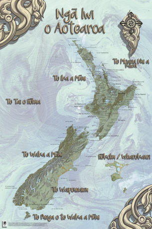
NGĀ IWI O AOTEAROA: iwi MAP, NEW ZEALAND MĀORI TRIBAL MAP AND TRADITIONAL GEOGRAPHIC NAMES
|
Ngā Iwi O Aotearoa Map is an authentic, researched and beautiful educational resource for display, a unique collector’s item.
The iwi map was created to help students to gain more understanding about New Zealand tribes and Māori names for our seas and regions. It was also an answer to the many requests for changes to be made to the old black and white iwi map that we had in TAKOA With the constraints of space, the map indicates primarily the approximate relation of iwi to geography. The Iwi Map reflects the dynamic nature of hapū -iwi relationships and boundaries that have been reclaimed or reasserted in and over time. |

|
The new map reflects the dynamic nature of hapū-iwi relationships and the boundaries and lands they have claimed and re-asserted in and over time - and the Waitangi treaty claims process.
Specifically, it gives an indication of the approximate relation of iwi, and some larger hapū, to geography and rohe. Although we haven't been able to accommodate all of your suggestions we love the positive feedback you have given us for the map. The map was created by Virginia Tamanui and the design process was led by Sjimmy Fransen. For this map we engaged the design skills of Maui Studios design team. We are now working on the second edition taking a whanau approach to the design and research process. The next edition should be ready end 2022. |
